I tried to sprinkle some of this into the trip account text, but this area is so fascinating that I want to include more info here.
"This is not a trip for beginners. The way is long, steep, and grueling. A strong hiker needs at least 12 hours to reach the high lakes. The average hiker takes 2 days. The rest never make it."
—102 Hikes in the Alpine Lakes, South Cascades, and Olympics (1972)
You start in the parking lot at 1600', then hit Nada Lake (5000'), followed by Snow Lakes at 5415'. The two Snow Lakes lie cupped between Mt. Temple (8292') to the east and Mt. McClellan (8364') to the west.
There is a low concrete dam between the two Snow Lakes, built back in the 1930's. The reason had something to do with guaranteeing a 'pure intake for the Leavenworth Fish Hatchery." (102 Hikes in the Alpine Lakes, 1972)
You follow a sketchy trail around the west side of the lakes to the base of a very steep slope, then following rock cairns steeply up towards Mt. Temple and Trauma Rim [Becky calls it 'Trauma Rib]. Here, you climb granite slabs up to the glorious Lower Enchantment Lakes basin. Go up another 500' and you'll find the rugged, rocky Upper Enchantment Basin.
100 Hikes in the Alpine Lakes (1985)
A USGS topographer named A.H. Sylvester discovered the area in 1908 and coined the name 'Enchantments.' Historical note: when Sylvester was here, almost the entire Upper Enchantment Basin was covered by the Snow Creek Glacier!
The lakes had official (boring) Forest Service names, but visitors to the area (most notably Bill and Peg Stark) proposed names more in keeping with the Enchantments designation: Leprechaun, Valkyrie, Rune, Talisman, Brynhild, and more. These alternate (and infinitely more fitting) names have grown increasingly more popular.
As of 1985, the Enchantments were so over-popular that necessary restrictions were put into place, including the following: no motorcycles, horses, dogs, and absolutely no fires (backpacking stoves only!) Party sizes were limited to six, toilets were built, and camping was limited to designated sites. Shortly after that, a reservation/permit system was instituted to further limit the hordes descending upon this fragile area.
CASCADE ALPINE GUIDE CLIMBING AND HIGH ROUTES, COLUMBIA RIVER TO STEVENS PASS
1973, Fred Beckey
(This section of notes roughly summarizes and paraphrases Beckey's info.) Mt. Stuart, monarch of the Wenatchee Mountain range and the 2nd highest non-volcanic peak in Washington State, lies 15-miles east of the Cascade Crest. This section of the Wenatchee range is commonly referred to as The Stuart Range and contains not only Mt. Stuart, but McClellan, Dragontail, Sherpa, Colchuck, and Argonaut peaks — as well as Little Annapurna.
The huge granite batholith underlying this area is about 16 miles by 13 miles in dimension and was intruded (uplifted) into the area about 120-million years ago. Over millions of years, erosion and weathering removed the lower softer rocks and exposed the harder granite. During the ice age, the Snow Creek Glaciers flowed down Rat, Snow and Mountaineer creeks into Icicle Canyon, further sculpting the area. But the glaciers didn't 100% cover the area and if you climb to the summits (like we did on Little Annapurna), you'll find ancient bedrock slabs.
The Enchantments consist of a system of fourteen lakes bounded to the north by Icicle Creek and to the south by Ingalls Creek. Icicle Creek is one of the deepest valleys in the Cascades at roughly 6,000' below summit levels. Ingalls Creek is a deeply evacuated U-shaped valley fed by five major southern tributaries coming down for origin points 5600-6200' above the valley floor.
Lyall's Larch grows here, turning bright gold in the fall.
"Early explorers of the area were miners, topographers and geologists Professor I. C. Russell made a high-level traverse along the Teanaway divide from Blewett townsite to Mt. Stuart in 1989. He also ascended the Ingalls Creek rim to overlook Snow Lakes. Mt. Stuart was included as one of five peaks in the Cascades marked on the earliest state and geological survey maps." (pg. 253)
Indian trading and hunting trails were certainly the first routes in this region.
LITTLE ANNAPURNA: 8,440'. "The Little Annapurna-Dragontail Plateau is a high crest which is a mass of coarse bedrock blocks. The eastern section of Snow Creek Glaciers lies to its north. The origin of the name is obscure, but obviously is taken from the shape of its Himalayan namesake. " There is a walk-up (hike) route up the north side from Crystal Lake and the Upper Ehchantment Basin.
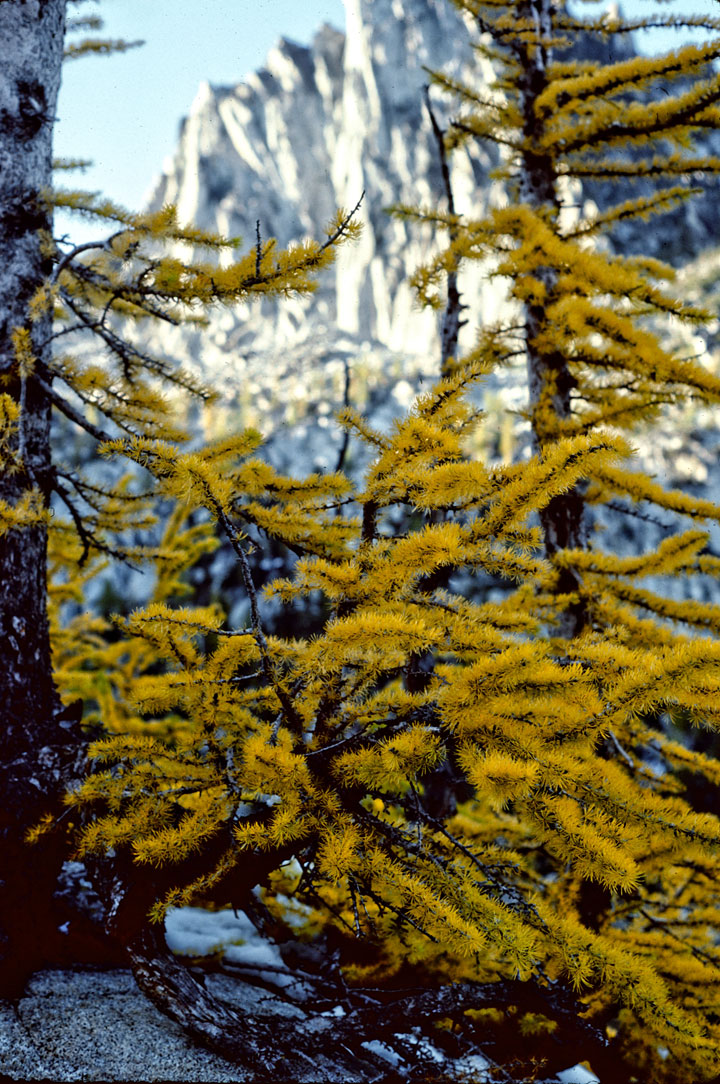
Lyall's Lark in October. Prusik Peak in background.